


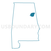
Calhoun County PUMA, Alabama
About
Outline

Summary
| Unique Area Identifier | 192090 |
| Name | Calhoun County PUMA |
| State | Alabama |
| Area (square miles) | 612.29 |
| Land Area (square miles) | 605.87 |
| Water Area (square miles) | 6.42 |
| % of Land Area | 98.95 |
| % of Water Area | 1.05 |
| Latitude of the Internal Point | 33.77170610 |
| Longtitude of the Internal Point | -85.82251330 |
Maps

Graphs
Select a template below for downloading or customizing gragh for Calhoun County PUMA, Alabama


Neighbors
Neighoring Public Use Microdata Area (by Name) Neighboring Public Use Microdata Area on the Map
- Etowah County PUMA, AL
- St. Clair & Blount Counties PUMA, AL
- Talladega, Cherokee, Randolph, Cleburne & Clay Counties PUMA, AL
Top 10 Neighboring County (by Population) Neighboring County on the Map
- Calhoun County, AL (118,572)
- Etowah County, AL (104,430)
- St. Clair County, AL (83,593)
- Talladega County, AL (82,291)
- Cherokee County, AL (25,989)
- Cleburne County, AL (14,972)
Top 10 Neighboring County Subdivision (by Population) Neighboring County Subdivision on the Map
- Gadsden CCD, Etowah County, AL (72,028)
- Anniston CCD, Calhoun County, AL (68,662)
- Jacksonville CCD, Calhoun County, AL (18,722)
- Alexandria-Webster Chapel CCD, Calhoun County, AL (11,730)
- Munford CCD, Talladega County, AL (10,201)
- Hokes Bluff CCD, Etowah County, AL (9,279)
- Ashville CCD, St. Clair County, AL (8,449)
- Centre CCD, Cherokee County, AL (8,252)
- Lincoln CCD, Talladega County, AL (7,771)
- Heflin CCD, Cleburne County, AL (7,621)
Top 10 Neighboring Place (by Population) Neighboring Place on the Map
- Anniston city, AL (23,106)
- Oxford city, AL (21,348)
- Jacksonville city, AL (12,548)
- Saks CDP, AL (10,744)
- Southside city, AL (8,412)
- Glencoe city, AL (5,160)
- Piedmont city, AL (4,878)
- Alexandria CDP, AL (3,917)
- West End-Cobb Town CDP, AL (3,465)
- Weaver city, AL (3,038)
Top 10 Neighboring Unified School District (by Population) Neighboring Unified School District on the Map
- Etowah County School District, AL (60,417)
- Calhoun County School District, AL (57,392)
- St. Clair County School District, AL (53,540)
- Talladega County School District, AL (49,716)
- Cherokee County School District, AL (25,989)
- Oxford City School District, AL (23,361)
- Anniston City School District, AL (23,106)
- Cleburne County School District, AL (14,610)
- Jacksonville City School District, AL (12,548)
- Piedmont City School District, AL (6,677)
Top 10 Neighboring State Legislative District Lower Chamber (by Population) Neighboring State Legislative District Lower Chamber on the Map
- State House District 40, AL (49,653)
- State House District 39, AL (46,905)
- State House District 36, AL (46,065)
- State House District 30, AL (44,979)
- State House District 35, AL (44,612)
- State House District 33, AL (43,809)
- State House District 28, AL (40,514)
- State House District 32, AL (38,800)
Top 10 Neighboring State Legislative District Upper Chamber (by Population) Neighboring State Legislative District Upper Chamber on the Map
- State Senate District 12, AL (142,431)
- State Senate District 13, AL (132,777)
- State Senate District 11, AL (125,111)
- State Senate District 10, AL (125,075)
Top 10 Neighboring 111th Congressional District (by Population) Neighboring 111th Congressional District on the Map
- Congressional District 6, AL (754,482)
- Congressional District 3, AL (681,298)
- Congressional District 4, AL (660,162)
Top 10 Neighboring Census Tract (by Population) Neighboring Census Tract on the Map
- Census Tract 105.01, Etowah County, AL (8,191)
- Census Tract 20, Calhoun County, AL (7,335)
- Census Tract 25.01, Calhoun County, AL (7,069)
- Census Tract 18, Calhoun County, AL (6,919)
- Census Tract 21.03, Calhoun County, AL (6,801)
- Census Tract 11, Calhoun County, AL (6,565)
- Census Tract 17, Calhoun County, AL (6,329)
- Census Tract 10, Calhoun County, AL (5,792)
- Census Tract 403, St. Clair County, AL (5,509)
- Census Tract 15, Calhoun County, AL (5,198)
Top 10 Neighboring 5-Digit ZIP Code Tabulation Area (by Population) Neighboring 5-Digit ZIP Code Tabulation Area on the Map
- 36265, AL (21,060)
- 36201, AL (20,156)
- 36207, AL (19,801)
- 36203, AL (18,799)
- 36272, AL (13,389)
- 36206, AL (11,427)
- 36264, AL (8,659)
- 35907, AL (8,345)
- 35096, AL (7,815)
- 35953, AL (7,319)